The Google route map has layers for the walking, off-road cycle and equestrian routes, each can be turned on or off. It also has layers for faculties along the route such as refreshments, camping and transport links.
The Icknield Way is a OS Maps Trusted Route Partner and has mapped sections of the route. The OS map allows to view the route against a Landranger or Explorer map backgrounds (with registration and/or subscription). Route maps can be taken off-line and GPX files downloaded.
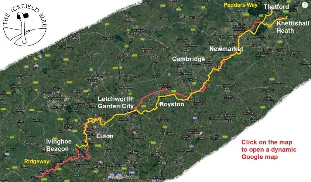
The menu links give further information about the route county by county. The walkers, off-road cycle and equestrian routes follow slightly different routes at places.
Walkers Route – OS map links
Days and Map references refer to the Icknield Way Path – Walkers’ Guide . Explorer OS Map numbers are the main maps covering the route there are a few short stretches on other maps.
| Day | Map Number | To/From | Distance (km/miles) | OS Map link | Explorer OS Map |
| Day 1 | Map 1-3 | Ivinghoe Beacon to Chalk Hill | 17.32km/10.8mi | OS Map | 181, 193 |
| Day 2 | Map 4-5 | Chalk Hill to Streatley | 17.55km/10.9mi | OS Map | 193 |
| Day 3 | Map 6-8 | Streatley to Ickleford | 16.40km/10.2mi | OS Map | 193 |
| Day 4 | Map 9-13 | Ickleford to Royston | 28.43km/17.7mi | OS Map | 193, 209 |
| Day 5 | Map 14-19 | Royston to Linton | 27.72km/17.2mi | OS Map | 209 |
| Day 6 | Map 20-23 | Linton to Cheveley | 25.74km/16.0mi | OS Map | 209, 210 |
| Day 7 | Map 24-27 | Cheveley to Icklingham | 22.11km/13.7mi | OS Map | 210, 229 |
| Day 8 | Map 28-32 | Icklingham to Knettishall Heath | 26.23km/16.3mi | OS Map | 229 |
| Day 2 Alt | Map 33-34 | Toddington Alternative | 6.69km/4.2mi | OS Map | 193 |
| Day 8 Alt | Map 35-36 | Barrows Corner to Thetford Alternative | 9.19km/5.7mi | OS Map | 229 |
Walkers Route
The Icknield Way Path – Walkers’ Guide contains detailed walkers route descriptions and clear maps, supplemented with notes on the geology, geomorphology, archaeology, flora and bird life along the Path, plus backup information on public transport in the area. ISBN 978-0-9521819-3-4. Only available from the Guidebook page of this website.
As well as the OS maps the GPX/KML file can be downloaded from this link walkers route and then from the link on the right. The OS maps have green diamonds highlighting the walkers route (not the riders route).
The OS maps are a little confused and in places show green diamonds for both the Icknield Way Path and the Icknield Way riders route. We have asked OS to only show the walkers route to avoid confusion.
Riders Route
The Icknield Way also has a riders route details of this are on our sister website – Icknield Way Trail. This has more details for off-road cyclists and equestrians.
Accessibility
The Icknield Way Walkers’ route is largely stile free. There are only four stiles, which are in Bedfordshire. Two are on Map 3 on the path between Sewell Lane and A505, these can be avoided by using Sewell Lane. The other two are Map 4 between Wingfield and the B5120, there is no easy stile free alternative.
Many sections of the Icknield Way are probably accessible to users with mobility issues using mobility scooters through to off-road trampers. The riders routes generally have less structures that may obstruct a tramper than the walkers route. We currently do not have the skills to survey the routes but would welcome any contact who would be able to properly assess and advise on accessibility. We believe these locations are most accessible:
- Chiltern Gateway Centre, Dunstable
- Sundon Hills Country Park, Bedfordshire
- Sharpenhoe Clappers, Bedfordshire
- Warden & Galley Hills, Bedfordshire
- Pirton to Ickleford, Hertfordshire
- Therfield to Royston, Hertfordshire
- Tuddenham to Icklingham, Suffolk
See Phototrials and Disabled Ramblers for more information for the type of information we would like to promote.
Great Chalk Way
The Icknield Way forms part of a family of multi-user routes from Dorset to Norfolk known as the Great Chalk Way.